File:Dartmoor, Becky Falls - geograph.org.uk - 438831.jpg
Jump to navigation
Jump to search
No higher resolution available.
Dartmoor,_Becky_Falls_-_geograph.org.uk_-_438831.jpg (640 × 480 pixels, file size: 163 KB, MIME type: image/jpeg)
Summary
| Description |
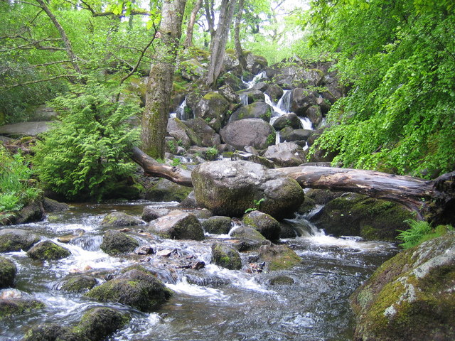
English: Dartmoor: Becky Falls From a strictly physical geographical point of view this is the Becka Falls waterfall on the Becka Brook, which is a tributary of the River Bovey. The water cascades here over a boulder-strewn bed with a fall of about 70 feet or about 20 metres.
However the land in which they occur is privately owned, and the owners have unsurprisingly turned the site into a tourist attraction in which the falls are the centrepiece of a woodland park containing a variety of different features such as a children's zoo, pony paddocks, and the inevitable gift shop. In the course of this commercialization the name of the falls has metamorphosed from Becka, as shown on the OS 1940s map, into Becky, as shown on the current OS map. The falls were first made accessible to the public in 1903, and the park's website is here http://www.beckyfalls.com/index.php Adult admittance in May 2007 was £5.75 per person. |
| Date | |
| Source | From geograph.org.uk |
| Author | Nigel Cox |
| Attribution (required by the license) | Nigel Cox / Dartmoor: Becky Falls / |
| Camera location | | View this and other nearby images on: OpenStreetMap |
|---|
_heading:270.00&language=en)
| Object location | | View this and other nearby images on: OpenStreetMap |
|---|
_heading:270.00&language=en)
Licensing

|
This image was taken from the Geograph project collection. See this photograph's page on the Geograph website for the photographer's contact details. The copyright on this image is owned by Nigel Cox and is licensed for reuse under the Creative Commons Attribution-ShareAlike 2.0 license.
|
This file is licensed under the Creative Commons Attribution-Share Alike 2.0 Generic license.
Attribution: Nigel Cox
- You are free:
- to share – to copy, distribute and transmit the work
- to remix – to adapt the work
- Under the following conditions:
- attribution – You must give appropriate credit, provide a link to the license, and indicate if changes were made. You may do so in any reasonable manner, but not in any way that suggests the licensor endorses you or your use.
- share alike – If you remix, transform, or build upon the material, you must distribute your contributions under the same or compatible license as the original.
File history
Click on a date/time to view the file as it appeared at that time.
| Date/Time | Thumbnail | Dimensions | User | Comment | |
|---|---|---|---|---|---|
| current | 07:31, 4 February 2011 | | 640 × 480 (163 KB) | GeographBot | == {{int:filedesc}} == {{Information |description={{en|1=Dartmoor: Becky Falls From a strictly physical geographical point of view this is the Becka Falls waterfall on the Becka Brook, which is a tributary of the River Bovey. The water cascades here over |
File usage
The following 2 pages use this file:
Global file usage
The following other wikis use this file:
- Usage on ceb.wikipedia.org
- Usage on en.wikipedia.org