File:Map Londinium 400 AD-de.svg
Jump to navigation
Jump to search

Size of this PNG preview of this SVG file: 598 × 599 pixels. Other resolutions: 240 × 240 pixels | 479 × 480 pixels | 766 × 768 pixels | 1,022 × 1,024 pixels | 2,044 × 2,048 pixels | 996 × 998 pixels.
Original file (SVG file, nominally 996 × 998 pixels, file size: 491 KB)
Summary
| Description |
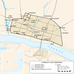
Deutsch: Karte des spätantiken Londons (um 400 n. Chr.). |
| Date | |
| Source | Own work, data based on image:Londinium3.jpg and image:London 1300 Historical Atlas William R Shepherd (died 1934).PNG. Image renamed from Image:Londinium.svg |
| Author | Fremantleboy |
| Other versions |
Derivative works of this file: |
.PNG)

|
This SVG file contains embedded text that can be translated into your language, using any capable SVG editor, text editor or the SVG Translate tool. For more information see: About translating SVG files. |

|
This map has been made or improved in the German Kartenwerkstatt (Map Lab). You can propose maps to improve as well.
|
Licensing
I, the copyright holder of this work, hereby publish it under the following license:
This file is licensed under the Creative Commons Attribution 2.5 Generic license.
- You are free:
- to share – to copy, distribute and transmit the work
- to remix – to adapt the work
- Under the following conditions:
- attribution – You must give appropriate credit, provide a link to the license, and indicate if changes were made. You may do so in any reasonable manner, but not in any way that suggests the licensor endorses you or your use.
File history
Click on a date/time to view the file as it appeared at that time.
| Date/Time | Thumbnail | Dimensions | User | Comment | |
|---|---|---|---|---|---|
| current | 20:56, 7 October 2023 | | 996 × 998 (491 KB) | Furfur | Anpassungen |
| 21:55, 26 January 2017 |  | 996 × 998 (468 KB) | Ras67 | black frame removed | |
| 10:45, 15 August 2007 |  | 996 × 998 (748 KB) | Bibi Saint-Pol | == Summary == {{Information |Description= {{de|Karte des spätantiken Londons (um 400 n. Chr.).}} |Source=Own work, data based on image:Londinium3.jpg and image:London_1300_Historical_Atlas_William_R_Shepherd_(died_1934).PNG. Image renamed f |
.PNG)
File usage
The following page uses this file:
Global file usage
The following other wikis use this file:
- Usage on arz.wikipedia.org
- Usage on be.wikipedia.org
- Usage on de.wikipedia.org
- Usage on eo.wikipedia.org
- Usage on es.wikipedia.org
- Usage on hu.wikipedia.org
- Usage on it.wikipedia.org
- Usage on lld.wikipedia.org
- Usage on nl.wikipedia.org
- Usage on pl.wikipedia.org
- Usage on sv.wikipedia.org