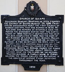
Church of Quiapo historical marker (Q25906814)
Jump to navigation
Jump to search
NHCP historical marker for Quiapo Church
| Language | Label | Description | Also known as |
|---|---|---|---|
| English | Church of Quiapo historical marker |
NHCP historical marker for Quiapo Church |
Statements
1939
0 references
Church of Quiapo (English)
0 references
910 Plaza Miranda (English)
The historical marker is located to the left of the main entrance of the church at the base of the left tower. (English)
0 references
Governor General Santiago de Vera founded the District of Quiapo August 29, 1586. Franciscan missionaries built the first Church, of bamboo and nipa, that was burned in 1639. Rebuilding and repairs at intervals gave the parish the stronger edifice that the earthquake of 1863 partially destroyed. The next Church, completed in 1899, was the work of Rev. Eusebio de Leon and Rev. Manuel Roxas, the latter raising ₱40,000.00 in contributons. A fire on October 30, 1929, left the Church only its scarred walls and belfry, and a parish committee headed by Doña Encarnacion Nakpil de Orense raised the funds for its reconstruction. Juan F. Nakpil, architect, drafted the plans for the reconstructed building. A famous image of Christ bearing the Cross, called the Nazarene, is the center of intense Friday devotions througout the year. (English)
0 references
Church of Quiapo historical marker
0 references
Sitelinks
Wikipedia(0 entries)
Wikibooks(0 entries)
Wikinews(0 entries)
Wikiquote(0 entries)
Wikisource(0 entries)
Wikiversity(0 entries)
Wikivoyage(0 entries)
Wiktionary(0 entries)
Multilingual sites(1 entry)
- commonswiki Category:Church of Quiapo historical marker


